Территория заповедника "Денежкин Камень" закрыта для посещения туристами. |
Search |
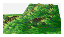
ReliefGeographically, the territory of the zapovednik is located in the North-Ural province of the Ural Mountain region, central zone. Geobotanically, it is located in the Northern Taiga zone. The diversity and structure of the biological complexes of the territory are a function of geomorphologic structure. The territory of the zapovednik is located on the eastern slope of the Ural Ridge (Northern Urals) on the intersection of two geomorphic regions. The Western part is the region that can be described as the mountain massif of the Northern Urals (The Main Ural Ridge); the central and eastern part is the region of solitary remnant mountains of the eastern slope of the Northern Urals (Denezhkin Kamen Mt.). The terrain is typical for moderate-height Mountains, peaks reaching 1200-1492 m, and average heights around 900-1100 m. Mt. Main Ural Ridge is an example of alpine type ridge with very steep slopes. The slopes of the Main Ural Ridge are totally covered by boulder bedrock screes; and a network of tectonic disturbances. The slopes are steep, with occasional tectonic scarps, but no terraces. In the upper parts of the ridge the slopes are convex. The area with glacial denudation at 900 m and above is not significant and is comprised of boulder talus, with no gravel. There are numerous snow patches of up to 300 sq m in diameter, and walls up to 6-8 m tall on the slopes of the ridge. The rivers run perpendicular to the main ridge stripe and accelerate the ridge fragmentation. The rivers running from the Main Ural Ridge have the following characteristics: a V-shaped valley, a high gradient, many cascades and an entrenched valley confinement, with exposed bedrock in the river sources. The valleys in lower elevations have boulder-cobble bed mountain stream channels and demonstrate steep accumulation of boulders and cobbles transverse to and spanning the channel, generally with a pool downstream that is scoured by the plunging (waterfall) flow over the step. Mt. Denezhkin Kamen is positioned separately, with peaks up to 1100-1492 m and has an isometric structure and a volcanic origin. It is comprised of intrusive mafic and ultramafic rock. The slopes are steep (up to 60 degrees), having numerous cliffs and drops with exposed bedrock. The slopes of Mt. Denezhkin Kamen are covered by boulder-cobble screes. There are several clearly defined glacial-erosion cirque formations in the upper parts of the Mt. Denezhkin Kamen slopes with terminal moraines of the Upper Pleistocene formed by boulder-cobble talus. There are no valleys with entrenched confinement. |
LanguagesНовостиВсе новости заповедника |


